
$1.89M
19240 Highway 42
Weirsdale, FL 32195
Listing updated: July 24, 2026 at 8:46 AM ET
Listing courtesy of Coastal Ventures Real Estate · Ashley Flatley · MLS #O6374372 · Active · 386-214-6714Property type
Year built
Building size
Lot size
Price / SF
Zoning
Days on market
About this property
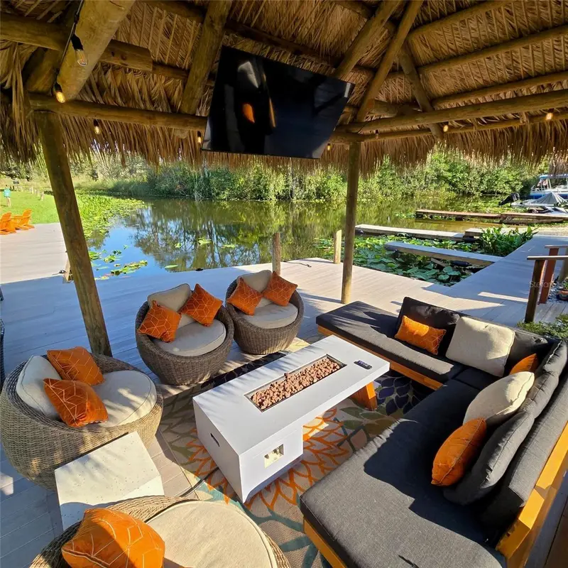
Private Waterfront Investment Opportunity | 18.23± Acres | Central Florida An exceptional 18.23-acre waterfront property located approximately 20 minutes from The Villages, Florida, offering a rare combination of income-producing assets, recreational amenities, and future development potential. This naturally secluded waterfront retreat provides access to the Harris Chain of Lakes and the Silver River, making it highly desirable for tourism, marina use, short-term rentals, or mixed-use development. When completed, the property will feature a diverse mix of accommodations and amenities, including two mobile homes, six cabins, and seven RV spaces with full hookups, creating multiple revenue streams. Additional improvements include a food truck, bathroom trailer, bar and entertainment area, stage for live events, and a private boat launch. The waterfront component is enhanced by 15 boat slips, catering to boating and fishing enthusiasts.
Virtual tour
Facts & features
- Property type
- Commercial Sale
- Sub type
- Mixed Use
- Status
- Active
- Days on market
- 52
- Subdivision
- Blue Heron Cove
- County
- Marion
- Year built
- 1938
- Building area
- 9,440 sq ft
- Price/sq ft
- $200.74
- Lot size
- 794,099 sq ft
- Buildings
- 2
- Road frontage
- County Road
- Annual taxes
- $22K (2025)
- Parcel #
- 50653-000-00
- Zoning
- PRV
- MLS #
- O6374372
Listing details
- Listing date
- 2026-01-14
- On market date
- 2026-01-16
- Original list price
- $1.90M
- MLS area
- 32195 - Weirsdale
- Status changed
- 2026-07-24
- Tax legal description
- SEC 20 TWP 17 RGE 25 THAT PART OF SW 1/4 OF SW 1/4 LYING S OF HWY 42 EXC W 175 FT EXC THAT PART OF SW 1/4 OF SW 1/4 DESC AS FOLLOWS: COM AT THE SE COR OF SW 1/4 OF SW 1/4 OF SEC 20 TH N 295.52 FT TO THE POB TH N 311.67 FT TH S 74-24-19 W 83.63 FT TH S 15-35-41 E 300 FT TO THE POB EXC THAT PART IN THE RIVER AND CANAL EXC ADDITIONAL ROW OF ST RD 42 AS SHOWN IN OR 1085-913 & LOT 1 BEING MORE PARTICULARLY DESC AS: COM AT THE SW COR OF SEC 20 AS SHOWN ON PLAT OF TANGLEWOOD (F-7) TH E 50 FT TH N 100 F T TO THE POB TH E 125 FT TH N 132.44 FT MOL TO THE SLY BNDY OF SR 42 TH SWLY ALONG ROW BNDY A CHORD DISTANCE OF 159.90 FT MOL TO THE PT OF INTERSECTION WITH THE SLY BNDY OF SR 42 AND THE ELY BNDY OF TANGLEWOOD DR TH S 32.70 FT MOL TO THE POB EXC ANY
Location
Directions
Hwy 44 to CR 42 property is on the right

Listings courtesy of Stellar MLS as distributed by MLS GRID
IDX information is provided exclusively for consumers’ personal, non-commercial use and may not be used for any purpose other than to identify prospective properties consumers may be interested in purchasing.
Based on information submitted to the MLS GRID as of July 24, 2026 at 8:46 AM ET. All data is obtained from various sources and may not have been verified by broker or MLS GRID. Supplied Open House Information is subject to change without notice. All information should be independently reviewed and verified for accuracy. Properties may or may not be listed by the office/agent presenting the information.
Ryan Solberg, Licensed Real Estate Broker · MaxLife Realty, LLC · FL Lic. #BK3354351 · Equal Housing Opportunity · Terms · DMCA